

How to use?
CityGO Maps runs online. The internet access ensures that everything is up-to-date at all times. No system update or upgrade is necessary.
When opening the map it loads at the optimal zoom level and center position. There might be more Pins (map points) on the map that you see first. You can zoom in and out and move in any direction. Circles indicate the city center or important touristic/city area. Pins show the location of each place on the map. The colour of the pins indicates its category:
Red (GO): attraction / temple / museum
Yellow (EAT): restaurant / café
Light blue (SLEEP): hotel
Purple (LIFESTYLE): shop / services
Green (HEALTH): health / sport
Dark blue (USEFUL): info / traffic / useful
Black (NIGHTLIFE): night bar / theatre
MOBILE / DESKTOP: The system works with different funcionality on different devices. The desktop and mobile version is mostly the same but manages features intelligently. Certain features only appear on moble and/or desktop. For example the location (Where am I?) function is completely unnecessary before travel at planning stage, while can be important during travel on the streets.
WHERE AM I? on mobile devices the location button appears at the upper left corner below the route buttons.

ROUTE: Route buttons are at the upper left corner of the map. These routes are manually created, thematic sighteeing routes. Routes are created based on personal experience and local expertise. The routes might include places which are hidden by other maps or not well known by travellers (off the beaten path) as well.
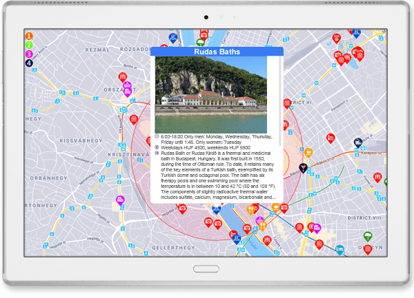
INFO WINDOW: Click/touch a Pin to open the info window. You can open several info window at once. Info windows close automatically after a while.
Contents of info windows: Name, Image, Description, Opening hours, Entrance fee, useful info (dress code… etc)

When opening the map it loads at the optimal zoom level and center position. There might be more Pins (map points) on the map that you see first. You can zoom in and out and move in any direction. Circles indicate the city center or important touristic/city area. Pins show the location of each place on the map. The colour of the pins indicates its category:
Red (GO): attraction / temple / museum
Yellow (EAT): restaurant / café
Light blue (SLEEP): hotel
Purple (LIFESTYLE): shop / services
Green (HEALTH): health / sport
Dark blue (USEFUL): info / traffic / useful
Black (NIGHTLIFE): night bar / theatre
ROUTE: Route buttons are at the upper left corner of the map. These routes are manually created, thematic sighteeing routes. Routes are created based on personal experience and local expertise. The routes might include places which are hidden by other maps or not well known by travellers (off the beaten path) as well.
INFO WINDOW: Click/touch a Pin to open the info window. You can open several info window at once. Info windows close automatically after a while.
Contents of info windows: Name, Image, Description, Opening hours, Entrance fee, useful info (dress code… etc)
MOBILE / DESKTOP: The system works with different funcionality on different devices. The desktop and mobile version is mostly the same but manages features intelligently. Certain features only appear on moble and/or desktop. For example the location (Where am I?) function is completely unnecessary before travel at planning stage, while can be important during travel on the streets.
WHERE AM I? on mobile devices the location button appears at the upper left corner below the route buttons.
Internet connection and web browser is required to operate the system.